Border, Barwon and Namoi River Systems
Image: Barwon River in high flow at Collerenabri. Photo credit: Rebekah Grieger
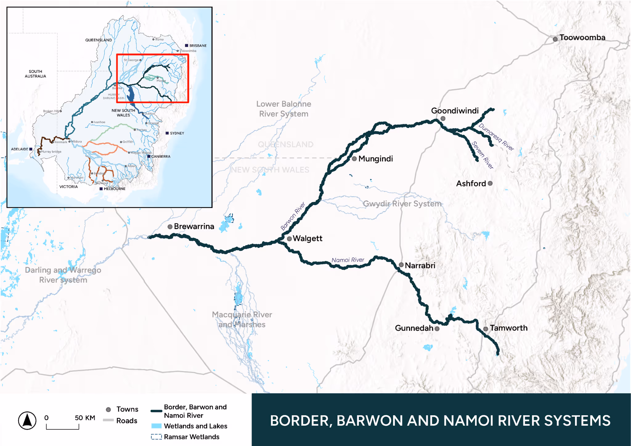
About the Area
The Border Rivers, Barwon River and Namoi River flow through the lands of the Bigambul, Euahlayi, Githabul, Kambuwal, Gomeroi/Kamilaroi, Kwiambul, and Ngarabal peoples forming songlines and dreaming tracks.
The Border Rivers catchment (~49,500 km2) comprises the Dumaresq, Severn, Macintyre and Weir group of rivers along the New South Wales and Queensland border. It is one of the northern-most catchments in the Murray–Darling Basin. The Namoi River catchment (~42,000 km2) is located south of the Gwydir River catchment and north of the Macquarie/Castlereagh catchment. The landscapes of these northern tributaries are diverse ranging from headwater streams in the tablelands (>1000 m elevation) down to the lowland sections of the floodplains to the south-west.
In contrast, the Barwon River in this Area refers to the section where the northern tributaries join, from the confluence of the Macintyre and Weir rivers south-west to the confluence with the Culgoa River.

Ephemeral floodplain vegetation flourishing in a roadside channel. Photo credit: Peta Zivec

Namoi River in low flow at Walgett. Photo credit: Rebekah Grieger
There are several major water storages across the rivers in the Border Rivers catchment and the Namoi catchment. These supply water for irrigation and have altered the natural flow and temperature regimes in sections downstream. Flows in the Barwon River are modified by water extraction from the river during flow events.
Environmental water across this region is used to support connectivity between the tributaries and the Barwon River to support the significant ecological values that occur across the region.
Our Work
Learn about the key activities taking place in this Area.

Native Vegetation
Native Vegetation monitoring and evaluation will focus on the riparian zone and floodplain vegetation when flooding occurs. Monitoring and evaluation will assess in-channel macrophytes, riparian canopy, floodplain canopy, groundcover vegetation, lignum shrubland, and the extent and duration of flooding caused by environmental water.
The evaluation of Native Vegetation will use spatial satellite data with field-based site assessments (transects for riparian and floodplain canopy and groundcover vegetation) to evaluate the role of environmental water in maintaining and improving native vegetation.

Waterbirds
Waterbird monitoring will not form a major component of the monitoring and evaluation for this Area. The presence and absence of waterbirds will be recorded along the vegetation transects in both spring and autumn across the 20 fixed sites. If environmental water contributes to overbank inundation waterbird breeding will be monitored and evaluated through responsive monitoring and will also draw on data collected from aerial waterbird surveys conducted by NSW Department of Climate Change, Energy, the Environment and Water and the University of New South Wales.

Native Fish
Native Fish monitoring will focus on how environmental water contributes to maintaining or improving native fish populations across the Border, Barwon and Namoi River Systems. Field sampling will involve electrofishing at 20 fixed main-channel sites in early autumn (March/April) each year. Sites span all rivers across the three catchments and are positioned from immediately below the storage dams to the bottom of each catchment and along the Barwon to detect differential influences of environmental flow delivery.

Cultural Outcomes
The Border, Barwon and Namoi team supports a culturally safe and staged approach to Cultural Outcomes, and as such the approach will mature and evolve with the building of new relationships and trust as it is built over the life of the program. We are working in collaboration with the Aboriginal Water Committee to the Northwest in the planning of the Cultural Outcomes Theme.

River Flows and Connectivity
The River Flows and Connectivity Theme in the Border, Barwon and Namoi Area will evaluate how environmental water contributed to the flow regime of each river system by evaluating the timing, duration and magnitude of flow events using gauged flow data and daily water accounting.

Knowledge Exchange and Community Engagement
The Border, Barwon and Namoi team lead a range of activities designed to share knowledge and information across the Flow-MER Program as well as to operational stakeholders, key landholders and stakeholder groups. We will share digital and printed factsheets to landholders and the local community that provide up-dates on monitoring and evaluation and observations of interest. As we develop our monitoring and evaluation program, we will provide education days which will allow networking and interaction with the local community to highlight the role of environmental water in sustaining local riverine ecosystems.
Research
Our research will map into the broader objectives of the northern Basin Commonwealth environmental water delivery, with focus areas around fish movement associated with connectivity events, food webs, the role of habitat complexity for small fish diversity and the maintenance of freshwater mussel populations.


Latest News
Annual reports, quarterly snapshots and implementation plans for the Border, Barwon and Namoi River Systems can be found on the Commonwealth Environmental Water Holder (CEWH) website.
News
%20flowers-%20(photo%20credit-%20Rebekah%20Grieger).avif)
%20.avif)
Webinars
Our Team
Griffith University has been engaged by the CEWH to conduct Flow-MER activities in the Border, Barwon and Namoi Area from July 2024 to June 2029.
Australian Rivers Institute, Griffith University
Partners

La Trobe University
NSW Government